BOUNDARY WATERS CANOE AREA WILDERNESS
JULY 1999
I had heard talk of the Boundary Waters and Quetico for years, the former being in the United States and the latter in Canada. Tales of the fantastic canoeing in these areas had stirred up dreams that were never realized until this summer.
I teamed up with a friend from Houston, who had been there twice before, and we planned a trip. Our permit allowed us to enter the wilderness on July 13, 1999 and exit on July 27, 1999--fifteen days for a tough, demanding, fabulous wilderness experience in one of the most beautiful, peaceful and serene areas of this country.
Motor boats prohibited and only a limited number of permits granted each day insured the peace and quiet of the area.
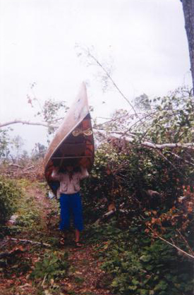
Our boat--an 18 foot We-no-nah kevlar Sundowner. Weight new 42 pounds, however this one had several repair patches that added a few pounds. We each had a large dry bag with straps for carrying on the back and a smaller day pack. Additionally there was a large food pack that I'm sure weighed in at over 80 pounds.
Our paddles hit the water at 12:50 PM on July 13 and we smoothly glided off on the clear placid surface of Baker Lake beginning our high adventure. Ten minutes later at 1:00 we came to the first portage. Portage means to carry. All gear and the canoe would have to be carried overland to the next lake. This was a short one, only 10 rods.
All portages are measured in rods, a rod being 16 1/2 feet, that being roughly the length of most canoes.
Our guide book stated that at this particular portage there was the option of lining the canoe up (or down) the rapid so we thought we would try this first. We paddled against the current in the rapid as far as we could and then stepped out ass deep into the cold water. After progressing a few more yards pulling and pushing the canoe through the rocks we noted a tree down across the stream. My friend, Marilyn, took off to see if we would be able to get by leaving me with the canoe.
There had been a terrible storm around the 4th of July that closed most of the portages and many of the campsites. The forest service had been busy clearing the portages and had given us a list of the ones that were open.
After waiting about half an hour I heard Marilyn calling to me that we couldn't get through by water to come on over to the portage. This was only 165 feet but several large fallen trees had been cut from the path. Signs of the storm were quickly evident.
We were now on Peterson Lake and we paddled through to Kelly Lake without any trouble, avoiding the short portage. The hill on the East side of Kelly Lake had been completely devastated by the storm. There was not a tree standing. They had either been blown over or snapped off ten or fifteen feet from the ground.
The 65 rod portage to Jack Lake had not been cleared. We decided to take the nearby campsite and tackle the portage the next morning.
Campsites are marked on the maps by red dots. Each campsite has a fire ring with a heavy metal grill and a toilet. The toilet is an outhouse without the house. It is usually several hundred feet from the fire ring well hidden back in the trees. This campsite had been hit by the storm and there were trees down everywhere. It was difficult to find a place to put the tent.
The next morning we had to saw branches off the downed trees on the portage. This took some time but we managed to get the canoe and our gear to Jack Lake. There we took a campsite with a good swimming area and swam and relaxed the rest of the day. Once when I was stepping out of the water after a good swim Marilyn said: "Look! There's a leech on your ankle." Sure enough there was. I yanked it off and then the spot bled for half an hour. That was the only one I got on the whole trip.
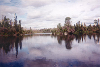
This was the boundary waters wilderness. Backbreaking portages and then finally the glimpse of the clear water of a placid and serene little lake with the shallow water near shore sprinkled with white and yellow water lilies enhanced by a background verdure of spruce, fir, birch, pine, hemlock and maple.
On the fourth day after several quarter mile portages and one three quarter mile we finally reached Brule Lake, the largest of our trip, eight miles long and two miles wide with fifty seven islands. We picked a great campsite on the east side of Cone Bay. The prevailing wind came out of the west so that blew the mosquitoes and flies into the woods.
We were paddling alongside one of the large islands when we spotted a bald eagle in a tree just about fifty feet from us. Then we spotted another eagle flying in. It was going with the wind and passed up the tree by about thirty feet, did a U turn and flew about fifteen feet past the tree when it spread its wings and let the wind carry it back to a perch in the tree right beside the first eagle. The first eagle evidently did not appreciate the company and immediately took off. The second eagle apparently took this as an insult because it began loudly squawking and kept it up for a couple of minutes.
We began to see more loons on this larger lake, also common mergansers with their red heads. The eerie "call of the loon" could be heard day and night.
Night temperatures were in the upper fifties and low sixties. Daytime in the upper seventies and low eighties. Water temperature was just right for swimming and we did a lot of that.
Brule Lake was so nice that we stayed there three days and four nights. One of our day trips from Brule was a seventeen mile paddle to Vern Lake. Our guide book listed Vern Lake as the most scenic spot in the whole area. When we got there we discovered that a forest fire had gone through and all we saw were charred stumps. We had left our campsite early and taken breakfast with us. We stopped on a little island and I cooked pancakes and made coffee.
On the eighth day we departed our homey campsite on Brule and set out for Cherokee Lake. There were four portages ahead of us. The first three were fairly easy ( if a portage can be easy) but the fourth was the worst of the whole trip. Only half a mile long but it crossed the Laurentian Divide. It was hilly, it was rocky, it was muddy, it was a bitch. There were numerous trees down; the put in on Cherokee Lake was very steep and difficult to manage, but we made it.
Cherokee Lake was a little smaller but even more beautiful than Brule. On Cherokee we enjoyed the best campsite of the trip. We stayed there four nights and did day trips. The swimming was the best yet.
There was a small island about a hundred yards from our campsite. One day we swam to it and discovered a really beautiful place. A large rock was sloping out of the water onto the bank so that we could just walk out of the water onto shore. The trees were well spaced and there was no underbrush; instead the ground was covered with a green moss that was like velvet and felt great to walk on barefooted.
On one of the day trips we made our way to Gordon Lake. There we saw beavers swimming to their lodge carrying beaver sticks in their mouths.
One day two guys came by and offered us a 22 inch northern pike which we graciously accepted. Then one said: "We have to hurry and get ours cleaned before the storm comes." I said: "What storm?" I was standing next to some trees that were hiding a huge black cloud. About twenty minutes later a wind came up, blew our canoe out of the water, rolled it over several times and pinned it against a tree. Later we discovered that it had blown a tree over. It did not fall to the ground because other trees held it up but the roots were about a foot out of the ground.
Filleted, pan fried and generously sprinkled with Tony Chachere's the fish was delicious.
We left Cherokee Lake via Cherokee Creek heading for Sawbill Lake. Four portages ahead of us. Finally about 3 PM we glimpsed the clear waters of Sawbill Lake. Part of Sawbill is outside the wilderness area and has a resort on it. It is also a popular put in point. This was a Saturday. We had to paddle around two hours to find an empty campsite.
The trip was winding down now. Sawbill to Smoke Lake and then to Burnt Lake where we spent the night. Toward dusk there was a very light drizzle that did not even call for rain gear. We saw a mama loon feeding two baby loons. She would dive down under water, come up with a small fish and feed it to one of the babies and then immediately repeat the process. Then Marilyn spotted something swimming out in the lake. Through binoculars we could make out that it was a cow moose. When we first saw it, it was about a half mile away. The moose kept swimming towards us and eventually passed within 50 feet of our campsite, then a couple hundred feet further it got out of the lake and walked off into the woods. This was the first moose I had ever seen.
On the morning of the fourteenth day we prepared for the 230 rod (3/4 mile) portage to Kelly Lake. This is where we met the "Boundary Water Babes". Six women, all married, all with children who for the past five years have been leaving their husbands with the children and spending a week canoeing the wilderness area. One of them had nothing to carry and offered to carry my pack, so I let her carry my pack while I carried the canoe.
One of the women, named Kathleen, told me that she owned all of the equipment and the others rented it from her. She said: "It's a good excuse, when it's time to go I tell my husband: "you know I have to go, it's business.""
Kelly Lake was where we camped the first night and this, our last night, would also be on Kelly Lake.
The next morning we packed up for the last time, paddled through Jack Lake, did the 10 rod portage to Baker Lake then the a ten minute paddle to the car.
It was a great experience.
That night in Ely at the Chocolate Moose Restaurant we treated ourselves to "Wild rice crusted walleye." After fifteen days of mostly dehydrated food it was truly delicious.
Would I go back to the boundary waters? You bet!!!
Hulin Robert